|


|
|||||||||||||||||||||||||||||||||||
 |
 |
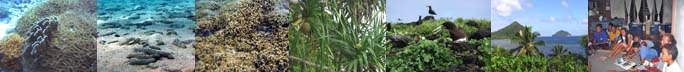
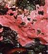
| Plate 10. Diadema Urchins. Courtesy of H20 Sportz |
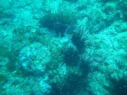
Plate 11. Giant Clam. Courtesy of Diane Walker. LRI Volunteer - Rotuma, October 2003 |
 |
|
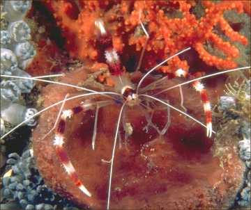
Plate 12. Banded Coral Shrimp Courtesy of Poseidon's Realm |
|
- There were a lot more coral-based invertebrates for 2004 than for 2003. Invertebrate diversity however decreased. Sand-based invertebrates such as Brown Sandfish and Green Teatfish were rarely encountered.
- Diadema urchins were the most abundant for 2004. Not only does Diadema have spines that are more needlelike, but also it actively roves in search of turf algae. Diadema keep the hard surfaces clean so coral larvae may get a chance to settle and recolonise reefs.
- Lobsters were not encountered on the daily dives mainly because they are nocturnal and there were no night dives conducted on this occasion.
4. DISCUSSIONS
- Rotuma's reef system is heavily exposed to the natural elements all year round. Yet it supports an abundance of coral species, fish and invertebrate life.
- As in 2003, coralline algae (CA) are still the dominant algae. Coralline algae do not respond well to phosphates, nitrates, and elevated CO2 levels (common pollutants). Increased levels will prevent or stun their growth.
- The high percentage of CA for 2003 suggested an ecosystem in recovery phase which give rise to an increase in mean live coral cover.
| Table 5. Mean percentage of live and dead coral cover for re-surveyed sites. For these sites, dead coral replaced live coral cover | ||||
Deep |
Shallow |
|||
2003 |
2004 |
2003 |
2004 |
|
| Dead Coral | .75 |
4.88 |
0 |
3.75 |
| Live Coral | 32.63
|
26.38 |
30.00 |
30.21 |
- In all 17 sites, live coral percentage cover went up at least 2% and this is reflected in the abundance of both common reef fish and commercially important fish. Live coral reefs also supported sponges and soft coral growth previously not encountered in the 2003 expedition.
- The overall data shows an increase in the mean shallow live coral cover by 8.4% [See Figure 3]. The 5 re-surveyed reefs had an increase of 0.21% [See Table 5] - a good indication that Rotuma's reefs are on a steadily recovering
- The mean Parrotfish counts and the mean live coral cover for shallow sites show a positive correlation in that populations are increasing.
- An abundance of coral-based invertebrates such as Diadema urchins, Giant Clams and Triton shells indicate good coral reef health.
- Commercial harvesting of fish and invertebrates still remains at a minimal, however, with the increasing pressure on the population to move out of subsistence fishing will dramatically decrease the invertebrate count.
- Drupella cornis, which feeds on Acropora branching corals and Crown-of-Thorns starfish, a coralivore both had zero counts on this recent expedition.
5. STATUS REPORT
5.1 GEOGRAPHY AND GENERAL INFORMATION
The main island of Rotuma (location: 12"35' S, 177"00' E) with an approximate land area of 43 sq. km. is located about 465km north of the Fiji Islands [1]. Rotuma has a central chain of forest-clad peaks and undulating coastal flats of varying width. Its volcanic soil is very rich, supporting luxuriant growth of flora. A narrow sandy isthmus at Motusa connects the two essentially distinct parts of the island. The highest point in the Rotuma group is approximately 255m above sea level and is on the island of Uea.
Rotuma has no rivers or streams, which add sediment to the sea. Well-developed fringing reefs surround the island and the reef flat is narrow in all but a few places notably the southeastern corner of Noa'tau district. The Oinafa coastline provides enough shelter where the jetty it located and has been repaired and extended in December of 2001. On LRI's first dive expedition in October 2003, water visibility was on average 15-20m on most days, which had minimal cloud cover and 10-15 knot winds from the southeast. Lopta had minimal visibility due to surge [2].
Ocean water temperatures recorded on dive computers range from 27"C to 29"C on the 2nd to 10th of October 2003. During the 2004 May expedition ocean water temperatures were 28-29"C.2 National weather data dating back to 1972 shows that Rotuma, lying in the cyclone belt, was frequented by storm to hurricane force winds (88-117kmph; >117kmph). In 1972, tropical cyclone Bebe killed 24 people in its path and devastated the island. [3]
In November 2002, a manta tow survey was carried out and soft corals were absent in 95 percent of total tows. There was an equal amount of live and dead coral. A large number of commercially important fish such as Humphead Wrasse (Cheilinus undulatus) was sighted on a number of occasions. There were no sightings of COT's for this period.
5.2 REEF HEALTH
Rotuma has experienced explosive population growth since the 1920s, growing from a total population of 2,112 in 1921 to 9,727 in 1996. The number of Rotumans on Rotuma was nearly the same in 1996 as it had been 50 years earlier (2,580 compared to 2,543), with migration draining off the net population increase. [4] Diets have mainly been sustained by this enormous oceanic resource and also through agriculture.
Population pressure has been a major environmental concern for the Rotuman Islanders. In relation to marine conservation, particularly the health of reef ecosystems, the islanders have reported the following observations: 1) smaller sized and reduced catch to date ie. inshore fisheries. 2) Reduction in fishing holes within the lagoon, clogged by an unknown fast- growing coral species, a local phenomenon called Kama. 3) Irresponsible dumping of household rubbish to the foreshore and 4) Coastal erosion and coral bleaching
According to the RCRCP 2003 Report, overall anthropogenic impacts were low to medium. There was no commercial harvesting of live rocks, live fish trade, invertebrates for curio sales, aquarium fishing, sewerage or industrial pollution, tourist snorkeling or dive operations. However, development is foreseeable in the nearby future and these concerns need to be raised.
The location of coral reefs, with respect to extreme weather patterns, affects coral health in Rotuma. For 8 months of the year, SE Trade Winds prevail on Rotuma after which it turns to the NE.2 From site description data, the southern reefs are exposed for two-thirds of the year compared to only 4 months for the northern reefs. Conditions for optimal coral growth favored reefs from Itu'muta to 'Ut'utu along the northern coast.
For 2003, the mean substrate cover for live coral was 26%, although algae dominated this at 47%. For the same sites re-surveyed in 2004, live coral cover increased to 28% and algae 42%. Of the total algae cover, half was coralline algae (CA) - an indicator that nutrient run-off was negligible.
CA is considered a fundamental part in every reef and marine system. The algae produce chemicals that promote herbivorous invertebrates. These in turn keep various seaweeds from growing which would otherwise smother the algae or keep them in the shade. The high density of Diadema urchins also ensures that turf algae is kept in check allowing germination of coral larvae.
Like plants, algae take up carbon for photosynthesis, and calcification where calcium is stored as calcium carbonate within the cell walls. It is also these cell walls that grow across the rock, structuring and holding together the reef set up. Corallines produce a form of magnesium that is beneficial for the invertebrates and the reef environment. Growing coralline algae is a sign of a healthy environment with good water values.
With the exception of Drupella cornis and Crown-of-Thorns Starfish, all other invertebrate taxa were relatively common [2]. Their low abundance on the reef correlates with a higher percentage of Acropora branching corals (ACB) on which they live off.
5.3 LOCAL FISHERIES
Not too long ago Rotumans depended heavily on marine resources for protein, which is now greatly supplemented with imported tinned foodstuff. Normally, fishers will catch within their districts only occasionally venturing into neighboring fishing grounds with permission from the relevant chief.
On LRI's 2004 expedition, a small-scale commercial fishing venture was being carried out on the island with the approval of the Rotuma Island Council where fishers would take their catch to the visiting fishing vessel. The total catch on each trip must be monitored and recorded for conservation purposes.
Apart from the 2000 coral bleaching event, past incidences of abuse of fishing methods in some areas and storm/hurricane damage has to some extent deteriorated the status of Rotuma's coral reef ecosystem. Also inshore coastal areas of Rotuma are under constant threat arising from extensive use of herbicides largely on farms. [2]
5.4 CONSERVATION ISSUES AND RECOMMENDATIONS
For a small island such as Rotuma, the local communities need more awareness on the significance of waste management. LRI is currently carrying out community awareness programmes in each district and have been successful in this regard. It is now crucial to reduce and completely discontinue the amount of non-biodegradable materials especially in coastal areas. Government authorities have in place laws to burying such refuse, however, implementation of these legislation is yet to be realized.
Data analysis in the course of the LRI 2004 expedition has concluded that inshore fisheries are sustainable for the moment. Conversely, existing fishing pressure over the next few years will ultimately result in far lower catches for inshore areas if the appropriate authorities and the local community take no serious measures. The implementation of no-take zones, especially for Juju and Pepjei District, needs to be in place other than traditional ones that are rarely executed.
There is no known environmental protection in all sites. Nevertheless, all forms of commercial fishing and harvesting should be banned at community level unless advised sustainable. The role of the Rotuma Island council is vital here.
The monitoring of the 17 permanent sites established during dive expeditions should be made an annual event to determine the status of the reef and that the local community be involved in this scheme.
5.5 REFERENCES
[1] Noa'ia 'e mauri. www.hawaii.edu/oceanic/rotuma/os/hanua.html
[2] Sidney Malo et al. Marine Studies Programme, USP. LRI Expedition & RCRCP
2003 Report.
[3] Ram Krishna. Fiji Meteorological Services, Nadi. Publication No.
2, 1981
[4] A. Howard and J. Rensel for the Fiji Constitutional Review Commission
in November 1995. Data from the 1996 Fiji Census were incorporated
on 1 December 1999.
[5] Coralline Algae. http://www.algone.com/coralline_algae_pf.htm .
LajeRotuma Initiative |